Erosion Visualization
Bald Head Island, North Carolina
Significant beach erosion has required the Village of Bald Head Island to monitor their beaches using GPS and underwater sonar profiling techniques. While profiling techniques are adequate, and efficient, at quantifying beach movement, they are difficult to interpret by a layperson and translate into poor visualizations of beach change. Using laser scanning techniques, Clarity Scanning offered a solution to this problem.
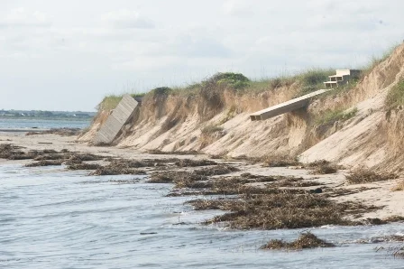
Beach erosion on Bald Head Island, North Carolina (2009).
Beach and bathymetry profiles (blue) with 6 inch aerial photography
Example of typical profile-to-profile change comparisons
Using 3D laser scanning, Clarity Scanning captured ultra detailed information about the beach, dunes and location of all beach front homes.
View of beach captured by laser scanning with photo colors overlaid on the point cloud
Highly detailed laser scan data showing tire tracks from the island turtle patrol
The laser scan was filtered for non-ground objects (vegetation, buildings, etc...), and "meshed" into a continuous surface.
The ground surface can then be combined with bathymetry and aerial photography to produce visualizations of the area and change over time.
Although not utilized on this project, our previous monitoring projects have provide stunning visualizations of erosion (below is an image of a mountain basin).